Statutory Instruments
2006 No. 2936
HIGHWAYS, ENGLAND
The Lincolnshire County Council Car Dyke Crossing Bridge Scheme 2004 Confirmation Instrument 2006
Made
31st October 2006
Coming into force in accordance with article 1
1. This Instrument may be cited as The Lincolnshire County Council Car Dyke Crossing Bridge Scheme 2004 Confirmation Instrument 2006 and shall come into force on the date on which notice that it has been confirmed is first published in accordance with paragraph 1 of Schedule 2 to the Highways Act 1980.
2. The Lincolnshire County Council Car Dyke Crossing Bridge Scheme 2004 (“the Scheme”) is hereby confirmed with modifications.
3. The Scheme as confirmed is set out in the Schedule hereto (including the plans) and copies of the Scheme with its accompanying plans are deposited at the offices of the Department for Transport, Floor 13 (IMD), Ashdown House, St Leonards on Sea, Hastings, East Sussex, TN37 7GA, and at the offices of the Lincolnshire County Council, Newland, Lincoln, Lincolnshire, LN5 7JN.
Signed by authority of the Secretary of State for Transport
J. Blackie
Regional Director
Government Office for the North East
31st October 2006
THE SCHEDULE
Lincolnshire County Council of County Offices Newland Lincoln LN1 1YL (hereinafter referred to as “the Council”) make this Scheme in exercise of their powers under Section 106(3) of the Highways Act 1980 and all other powers enabling them in that behalf.
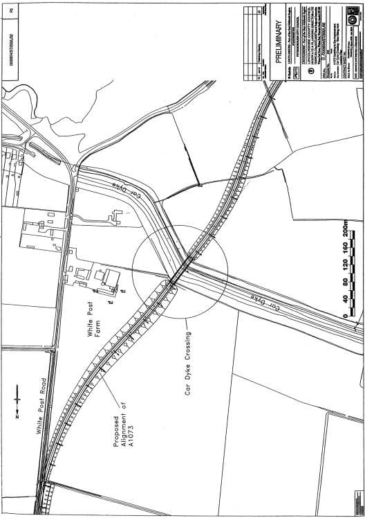
1. The Council are authorised to construct over the navigable waters of the Car Dyke the bridge specified in the Schedule to this Scheme as part of the highway which they are proposing to construct between Spalding and Eye.
2. The Scheme may be cited as the Lincolnshire County Council Car Dyke Crossing Bridge Scheme 2004.
THE SCHEDULE TO THE SCHEME PLANS AND SPECIFICATIONS OF THE CAR DYKE CROSSING BRIDGE
The location and general design of the Bridge are shown on the plans numbered B/0009504/ST/205/L/02 and B/0009504/ST/205/L/01 attached to this Schedule.
Points of Commencement and Termination
From a point on the south bank of the Car Dyke approximately 166 metres to the south west corner of White Post Farm as indicated on the attached location plan.
To a point on the north bank of the Car Dyke approximately 121 metres to the south west corner of White Post Farm as indicated on the attached location plan.
Span
A single span of 73.5 metres.
Headway
Not less than 10.1
Waterway
A minimum clear navigable waterway of approximately 3 metres.

S.I. 1981/238 .
S.I. 1981/238 .