Statutory Instruments
2007 No. 11
HIGHWAYS, ENGLAND
The Borough Council of Sandwell (Watery Lane Canal Bridge) Scheme 2003 Confirmation Instrument 2007
Made
3rd January 2007
Coming into force in accordance with article 1
1. This Instrument may be cited as The Borough Council of Sandwell (Watery Lane Canal Bridge) Scheme 2003 Confirmation Instrument 2007 and shall come into force on the date on which notice that it has been confirmed is first published in accordance with paragraph 1 of Schedule 2 of the Highways Act 1980.
2. The Borough Council of Sandwell (Watery Lane Canal Bridge) Scheme 2003 (“the Scheme”) is hereby confirmed with modifications.
3. The Scheme as confirmed is set out in the Schedule hereto (including the plan) and copies of the Scheme with its accompanying plan are deposited at the offices of the Department for Transport, Floor 13 (IMD), Ashdown House, St Leonards on Sea, Hastings, East Sussex, TN37 7GA, and at the offices of the Borough Council of Sandwell at Sandwell Council House, Freeth Street, Oldbury, West Midlands B69 3DE.
Signed by authority of the Secretary of State for Transport
J. Blackie
Regional Director
Government Office for the North East
3rd January 2007
THE SCHEDULE THE BOROUGH COUNCIL OF SANDWELL (WATERY LANE CANAL BRIDGE) SCHEME 2003
The Borough Council of Sandwell (hereinafter referred to as “The Council”) makes this scheme in exercise of its powers under section 106(3) of the Highways Act 1980 and of all other powers enabling them in that behalf:-
1. The Council is authorised to construct the bridge to form the route of Watery Lane over the navigable waters of the Birmingham Canal near Tipton in the Borough of Sandwell in the position and dimensions which are indicated in the Schedule and Plan annexed hereto as part of the highway they are proposing to improve between Queens Road and Alexandra Road in the Borough of Sandwell in the County of West Midlands.
2. The newly constructed bridge will replace the existing bridge over the said canal.
3. This scheme may be cited as The Borough Council of Sandwell (Watery Lane Canal Bridge) Scheme 2003.
THE SCHEDULE TO THE SCHEME
Plans and specifications of the Watery Lane Canal Bridge
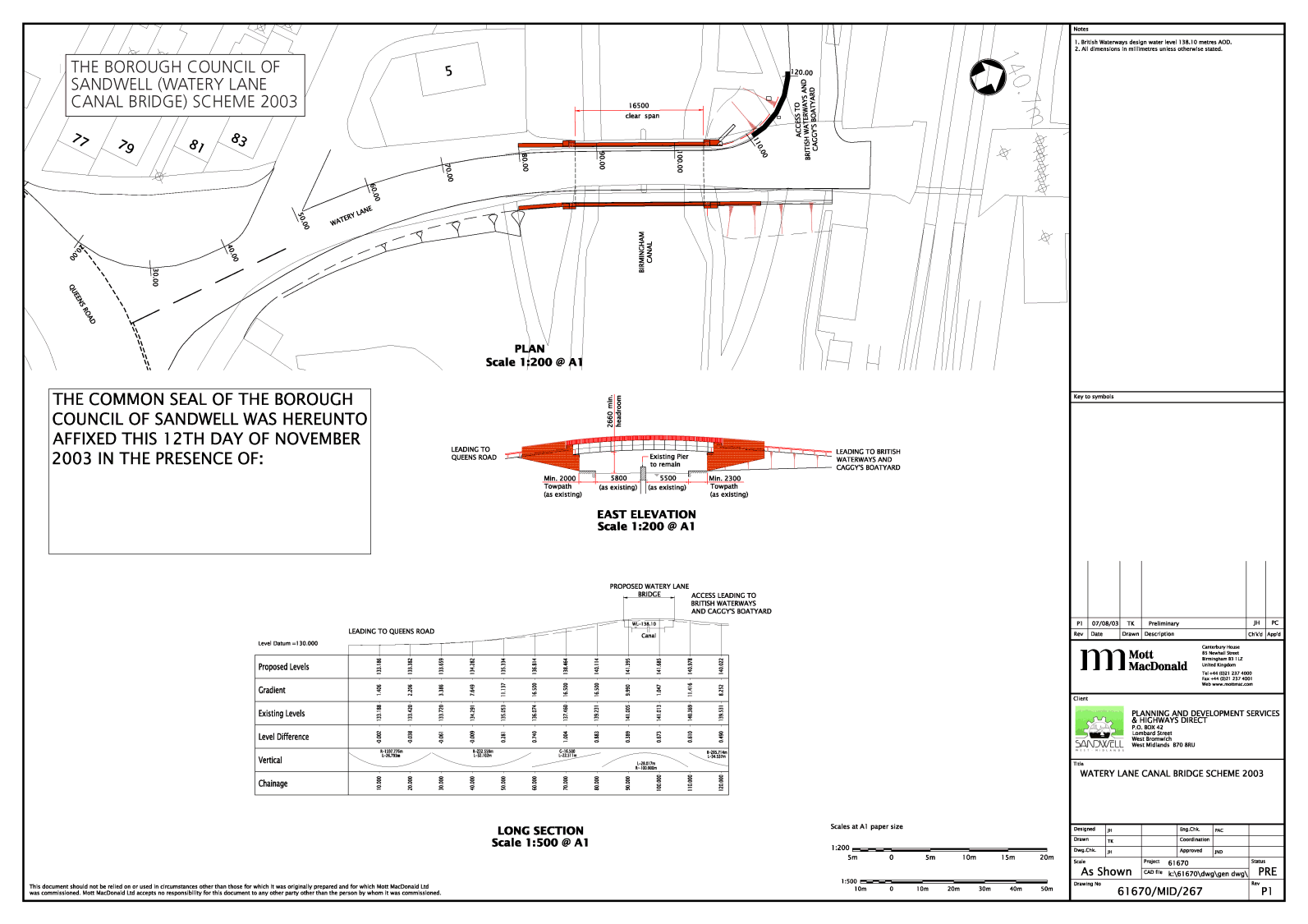
The location and general design of the Bridge are shown on the plan numbered 61670/MID/267 Rev P1 marked “The Borough Council of Sandwell (Watery Lane Canal Bridge) Scheme 2003” sealed with the Common Seal of the Council deposited at the offices of the Council and of the Secretary of State for Transport and attached hereto.
| Position: | The bridge is located at the inter-section of Watery Lane with the Birmingham Canal approximately 500 metres east of Tipton Town Centre in the Borough of Sandwell from a point 61 metres from the junction of Watery Lane and Queens Road, the bridge will extend 16.5 metres north over the Birmingham Canal to a point 29 metres south of the West Coast Main Line Railway. |
| Dimensions | |
| Spans: | There is a clear span of 16.500 metres (minimum) |
| Waterway: | The waterway is split into two by an existing central pier. |
| The widths of the two sections are 5.80 metres and 5.50 metres respectively. | |
| Minimum Head Room: | The minimum headroom under the bridge is 2.660 metres above British Waterways design water level of 138.10 metres AOD. |
| The bridge will be 7.1 metres wide overall and will carry a 5 metre wide single carriageway with a 0.6 metre wide hard strip and a footway of 1.5 metres width on either side. | |
SI 1981/238 .
SI 1981/238 .